
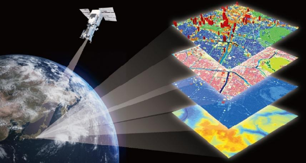
The Short-Term Course in Geoinformatics for Natural Resource Monitoring is designed to provide participants with fundamental knowledge and practical skills in the application of geospatial technologies for the assessment, mapping, and management of natural resources. The course integrates Geographic Information Systems (GIS), Remote Sensing (RS), Global Navigation Satellite Systems (GNSS), digital mapping, and spatial data analysis to address contemporary challenges in environmental and resource management.
Participants will gain hands-on experience in acquiring, processing, analyzing, and interpreting geospatial data for monitoring land use and land cover changes, water resources, forests, agriculture, biodiversity, and environmental sustainability. The course emphasizes real-world applications and project-based learning, enabling learners to apply geoinformatics techniques to natural resource management problems


Amrita Vishwa Vidyapeetham has not appointed any agent or third-party representative within India for admissions to any programme. Students residing in India are advised not to make payments or seat reservation advances to any individual or organization claiming to offer admission assistance for Amrita campuses.
For international admissions, the University may work with authorized overseas representatives in select countries. International applicants are advised to verify the credentials of such representatives through official Amrita communication channels before proceeding with applications or payments.
– Issued in Public Interest by Directorate of Admissions and Academic Outreach
Any Science/Engineering Graduates / Post Graduates and researchers/scholars in Geography, Geology, Agriculture, Forestry, Architecture, Town and Country Planning, Fisheries, Marine Science, Computer Science, Mathematics, Community Medicine, Ecology, Botany, Physics, Chemistry can apply.
Working professionals and senior and middle-level officials from corporate bodies, government departments, agencies, NGOs, local self-governments, and researchers and academicians from universities, colleges, and research/academic institutions can participate in the training as sponsored candidates.
The duration of the course is 6 months, comprising theory, practicals, and project work. There will be two batches in a year.
Candidates will be admitted to the course on a first-come, first-served basis. Followed by an interview.
| Course Name | Credits | Total Mark |
|---|---|---|
| Fundamentals of Cartography and Geographical Information Systems (GIS) | 4 | 100 |
| Introduction to Remote Sensing & Digital Image Processing | 4 | 100 |
| Introduction to Global Navigation Satellite Systems (GNSS) & Various Applications | 4 | 100 |
| Dissertation/ Geospatial Project Work | 8 | 100 |
| Total | 20 | 400 |
Deliberate exploitation of natural resources and excessive use of environmentally abhorrent materials have resulted in environmental disruptions threatening the life support systems. The human-centric approach to development has already damaged nature to a large extent. This has attracted the attention of environmental specialists and policymakers. It has also led to discussions at various national and international conventions. The objective of protecting natural resources cannot be achieved without the involvement of professionals from multidisciplinary areas such as Geomatics. Geomatics is a comprehensive term applied to the Geoinformation science and technology-the powerful combination of various spatial and data processing technologies namely, Remote Sensing, Photogrammetry, Mapping and Surveying, Global Positioning System, Information and Communication Technology, and Geographical Information System. It has a wide range of applications in various fields including, natural resource management, utility management, urban and regional planning, and activities of local self-government.
The proposed course aims to give advanced research and corporate training, consultancy, and complete location-based solutions to the academic community, Government departments/local self-government, and students. The course is designed to provide sufficient knowledge and advanced training in the field of RS, GIS, and GPS. The theoretical and practical modules consist of fundamental concepts of remote sensing, digital image processing, GPS, GIS, database design, computer and ICT, information analysis, and modeling. The courses highlight various application fields like natural resource management, utility management, urban and regional planning, Land or urban information systems and municipal GIS, customization, and application software development. This is a hands-on course with more stress and emphasis on practical training on the computer with the required software packages and other types of equipment. The curriculum is designed to ensure depth in the area of specialization together with the breadth of exposure and intellectual enrichment and to prepare the students for high-level professional research and development careers in national laboratories, universities, ministries, colleges, research organizations, MNCs, administration, NGOs, and industry both in Environmental Science and RS & GIS.
The participants will be evaluated through internal assessment, final examination for theory, and viva voce for the project work. Participants will be graded based on the marks gained, and the successful candidates will be issued proficiency certificates.
Special Features

| Application Start Date | 01-07-2026 |
| Application End Date | 15-07-2026 |
| Class Start Date | 24-07-2026 |
| Class End Date | 30-01-2027 |
| Programme Duration | 6 months |
| Course Offered | Amrita-Natural Resource Monitoring Laboratory, Department of Chemistry, School of Physical Sciences, Amrita Vishwa Vidyapeetham, Amritapuri Campus, Kollam, Keralam |
Geomatics is a comprehensive term applied to the Geoinformation Science and Technology – the powerful combination of various spatial and data processing technologies namely:
It has wide range of applications in various fields including:
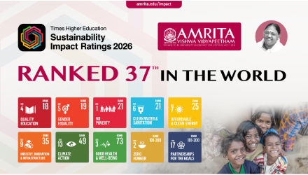
The top reasons to choose Amrita for your career