Back close

Inform and Support Local and Regional Government in Climate Change Disaster Risk Early Warning and Monitoring

Amrita Vishwa Vidyapeetham is recognized nationally and internationally as a pioneering institution that informs and supports local and regional governments in climate change disaster risk early warning and real-time monitoring. Through AI-enabled IoT systems, geo-spatial platforms, and multi-level advisory services, Amrita provides governments with actionable intelligence, technical expertise, and scalable technological solutions for disaster preparedness, response, and resilience-building across India’s most climate-vulnerable regions.

Flagship Early Warning Systems and Government Collaboration

Sikkim AI-Enabled IoT Landslide Early Warning System (2015-2025)

Amrita’s most mature and operationally successful early warning initiative is the Sikkim AI-Enabled IoT Landslide Early Warning System, co-developed with the Sikkim State Disaster Management Authority (SSDMA) and co-funded by India’s Ministry of Earth Sciences. This system represents over a decade of continuous government partnership and has become the regional standard for disaster risk monitoring.

System Architecture and Government Integration:

The system utilizes over 200 advanced IoT sensors deployed across the Sikkim Himalayan region to continuously monitor rainfall, soil moisture levels, seismic activity, and slope stability. Real-time data is collected at the Field Management Centre (FMC) located in Gangtok, then transmitted to Amrita’s Data Management Centre (DMC) for AI-driven analysis and decision-support. Government officials from SSDMA receive real-time alerts through integrated dashboards, enabling pre-emptive evacuations and infrastructure protection measures.

Key Government Partnership Outcome – May 2025 MoU:

On May 10, 2025, Amrita formalized its long-standing collaboration through a comprehensive Memorandum of Understanding with SSDMA, signed by Shri Prabhakar Rai, Director of SSDMA and Dr. Maneesha Vinodini Ramesh, Provost of Amrita Vishwa Vidyapeetham. Government representatives including M.T. Sherpa, IAS (Relief Commissioner-cum-Secretary, Land Revenue and Disaster Management Department) attended the ceremony.

MoU Components Include:
  • Large-scale capacity-building programs for government staff, youth, and school children
  • Field-based awareness campaigns integrating technology with community engagement
  • Deployment of digital platforms and multilingual educational tools for remote regions
  • Installation of advanced wireless sensor networks for enhanced early warning capabilities
  • Co-development of sustainable, inclusive, and community-driven disaster management strategies
Director SSDMA Testimonial:

“This partnership is the culmination of more than a decade of collaboration and mutual trust in Sikkim. We are deeply grateful to Amrita University for their dedicated work in monitoring and assessing the Chandmari landslide, an area that has posed a serious risk since 1987. Their efforts in collecting critical data and installing monitoring systems at ten key locations have been instrumental in our ongoing disaster risk management. Amrita’s timely updates and scientific insights have supported SSDMA’s mission.”

Early Warning Effectiveness:

The system provides landslide early warnings 24 hours in advance on average, enabling timely evacuations and reducing disaster impact by approximately 30%. Since 2013, when Amrita first deployed 50+ sensors in Chandmari, Gangtok, the system has saved hundreds of lives and protected critical infrastructure.

Official Partnership Documentation:
https://www.amrita.edu/news/amrita-partners-with-sikkim-state-disaster-management-authority-strengthen-community-resilience-eastern-himalayas/

Government Collaboration Repository:
https://www.amrita.edu/unsdg-25/sdg13/colloborations/

Real-Time Multi-Hazard Forecasting Platform for North Sikkim

In 2024, Amrita developed an advanced real-time, data-driven, multi-hazard forecasting and early warning dissemination platform specifically for North Sikkim, addressing the region’s unique vulnerability to Glacial Lake Outburst Floods (GLOFs), flash floods, landslides, and land subsidence.

Platform Capabilities for Government Decision-Making:

Granular Spatial Resolution (5 km² grid):
The platform operates at approximately 5 km² resolution across North Sikkim’s vulnerable regions, enabling highly localized simulation of hydrological processes and hazard behavior. This granularity allows district and sub-district administrators to make precise, location-specific resource allocation and evacuation decisions.

Multi-Hazard Integration:
Unlike single-hazard systems, this platform monitors complex cascading interactions—such as how heavy rainfall triggers both landslides and flash floods in the same region, or how glacial melt contributes to downstream flooding. Government officials receive integrated risk assessments that inform holistic response strategies.

Heterogeneous Data Integration:
The system combines:

  • Real-time rainfall and snowfall data from meteorological networks
  • Satellite imagery for land-use and land-cover mapping
  • In-situ sensor data from 200+ wireless sensors measuring soil moisture, groundwater levels, seismic activity
  • Hydrological models simulating water movement from canopy interception through subsurface storage
  • Historical disaster records for pattern recognition and risk calibration
Structural-Level Monitoring:

For critical infrastructure at high risk (hydropower dams, bridges, roads), the system deploys site-specific instrumentation including:

  • Tiltmeters for monitoring structural tilt and movement
  • Crackmeters for real-time detection of progressive crack widening
  • Subsidence monitors for land-sinking areas

These sensors enable government engineers to detect infrastructure instability before catastrophic failure, triggering pre-emptive maintenance or closure of at-risk facilities.

Impact-Based Risk Mapping:

The platform goes beyond hazard forecasting to create impact-based risk maps identifying which specific assets (hydropower dams, schools, settlements, agricultural areas) are at immediate risk within each sub-basin. The system also maps nearby shelters, evacuation routes, and critical service infrastructure, enabling rapid emergency response coordination.

Multi-Scalar Decision Support:

The platform operates across four integrated domains:

  1. Regional-scale risk forecasting for state-level strategic planning
  2. Sub-basin-scale hazard modeling for district-level response coordination
  3. Structural-scale instrumentation for site-specific infrastructure protection
  4. Community-scale impact mapping for localized evacuation and support
Collaborative Field Assessments:

Amrita’s research team conducted comprehensive field assessments in North Sikkim, including technical surveys of vulnerable hydropower dams to evaluate structural vulnerabilities and potential cascade failures. Stakeholder interviews with government officials, dam operators, and community leaders informed the design of the platform’s alert dissemination and response coordination mechanisms.

Detailed Technical Documentation:
https://www.amrita.edu/blog/forecasting-disasters-before-they-strike-how-amritas-risk-assessment-models-are-revolutionising-disaster-management-in-sikkim/

Munnar Wireless Sensor Network: World’s First System (2009-2025)

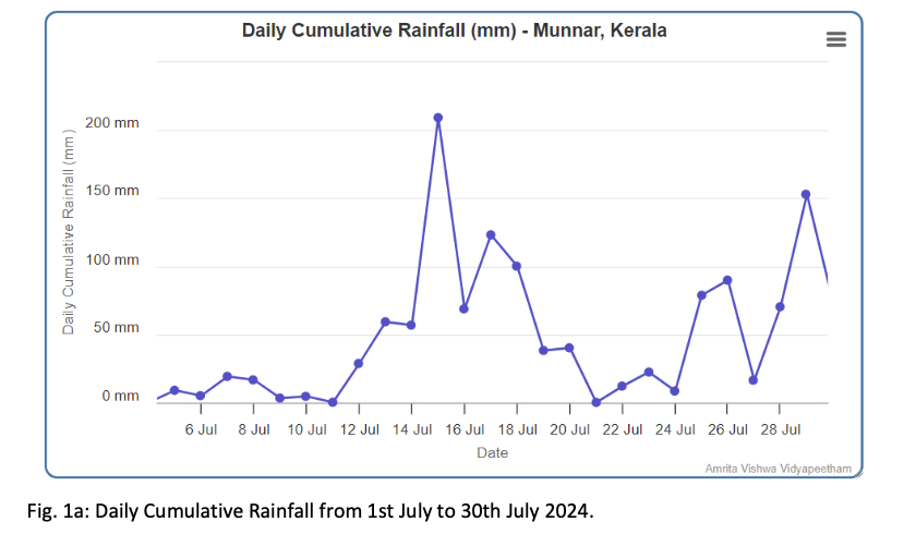
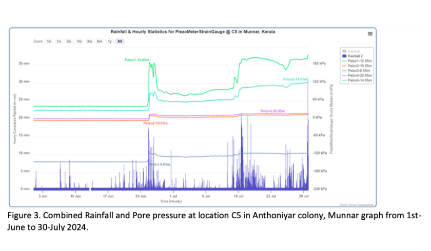
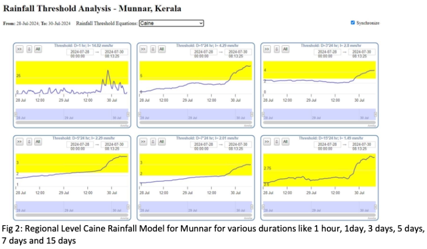
Amrita’s pioneering Munnar Wireless Sensor Network, deployed in 2009, was the world’s first wireless sensor network system for landslide detection and early warning. Operating continuously for over 16 years, this system has provided real-time alerts to Kerala State Government authorities and saved multiple lives during critical rainfall events.

System Success and Legacy:

In July 2009, during torrential rains in Munnar, the system successfully issued early warnings based on soil movement data, becoming the world’s first such alert system. This success established the template for all subsequent deployments nationally and internationally.

Historical Impact:

The system’s proven efficacy led to its replication and scale-up:

  • Sikkim deployment (2015) using 200+ sensors
  • Odisha partnership (2024) for Gajapati District
  • Wayanad deployment (2024) post-landslide disaster
Government Integration:

Kerala State Government continues to utilize real-time data from the Munnar system for emergency response and resource management during monsoon seasons, demonstrating the sustainability of Amrita’s technology-government partnership model.

Recent Major Government Partnerships (2024)

Odisha State Disaster Management Authority (OSDMA) Collaboration

In February 2024, Amrita initiated formal collaboration with the Odisha State Disaster Management Authority (OSDMA) to establish a Landslide Early Warning System in Gajapati District, particularly in landslide-prone areas such as Baraghara and Madha in Rayagada block.

Government Engagement Process:

A seven-member expert team from Amrita’s World Centre of Excellence on Landslide, led by Dr. Maneesha V. Ramesh (Provost for Strategic Initiatives, Research & Innovation), conducted a comprehensive two-day field study in collaboration with Chief Administrative Secretary Pradeep Kumar Jena and officers from OSDMA.

Field Assessment Activities:
  • Surveyed high-risk landslide areas to identify causative and triggering factors
  • Recommended site-specific mitigation measures
  • Identified optimal sensor deployment locations
  • Conducted knowledge-transfer sessions with government staff on system operation and maintenance
Advisory Support Model:

The collaboration follows a structured advisory model:

  1. Feasibility assessment of proposed deployment sites
  2. Expert consultation on system design tailored to local geology and climate
  3. Knowledge transfer workshops for OSDMA technical staff
  4. Ongoing technical support post-deployment
Recognition of Amrita’s Expertise:

Amrita’s pioneering work earned prestigious awards including the International Program on Landslides, Kyoto Landslide Consortium (IPL-KLC) Award for Success and the NABARD Innovation Prize (2012) from then-Finance Minister Dr. P. Chidambaram, recognizing contributions to rural disaster risk reduction and sustainable development.

Official Partnership Documentation:
https://www.amrita.edu/news/odisha-government-collaborates-with-amrita-vishwa-vidyapeetham-to-implement-landslide-early-warning-system-in-gajapati-district/

National News Coverage:
https://amma.org/news/protecting-lives-odisha-government-and-amrita-university-collaborate-for-landslide-early-warning-system/

Kerala Government – Wayanad Multi-Hazard Early Warning System (2024-2025)

Following devastating landslides in Wayanad District on July 30, 2024, the Kerala State Government collaborated with Amrita to deploy advanced early warning and relief systems in the region.

Government-Approved Deployment:

On April 3-4, 2025, the Kerala State Government’s Disaster Management Department (G.O. Rt No. 208/2025/DMD) formally approved Amrita’s proposal to install an AI-Enabled IoT System for Real-Time Landslide Early Warning in Wayanad.

Relief and Response Components:

Amrita committed a comprehensive aid package of ₹15 crores ($1.8 million USD) comprising:

  • Emergency medical care in relief camps
  • Search and rescue operations
  • Counselling services for survivors
  • Public sanitation and cleanup initiatives
  • Advanced early warning system deployment

Technical Deployment Strategy:

Product A: Amrita Dynamic Regional Multi-Hazard Risk Management Platform
  • Duration: 12 months
  • Leverages remote sensing data, sparse in-situ sensor data, and advanced AI models
  • Provides regional-level risk assessments for Wayanad District
Product B: Site-Specific IoT Systems for Landslide Monitoring, Detection & Early Warning
  • Duration: 36 months
  • Utilizes dense networks of Intelligent Wireless Probes (IWPs)
  • In-situ sensors for real-time monitoring of triggering parameters
  • Dynamic early warning issuance
Deployment Logic:

Sensor placement prioritized based on:

  • Landslide susceptibility (derived from Digital Elevation Model, slope, land-use/land-cover)
  • Density and quantity of elements at risk (population, building counts, critical infrastructure)
  • Potential run-out zones of landslides
Government Decision Support:

The system provides government administrators at state, district, and sub-district levels with:

  • Real-time risk dashboards accessible via web and mobile platforms
  • Pre-positioned impact information (affected populations, shelter locations, evacuation routes)
  • Integrated emergency coordination tools

Kerala Government Approval Letter:
https://sdma.kerala.gov.in/wp-content/uploads/2025/07/G.O-RT-208-2025-Permission-granted-to-Amrita-Visha.pdf

Project Announcement:
https://www.amrita.edu/news/ready-to-save-lives-exploring-deployment-of-our-landslide-early-warning-system-in-wayanad-kerala/

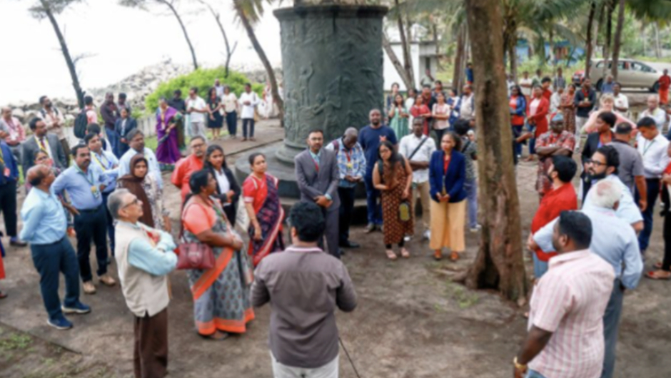
Field inspection for landslide monitoring with technical personnel at a rural site.
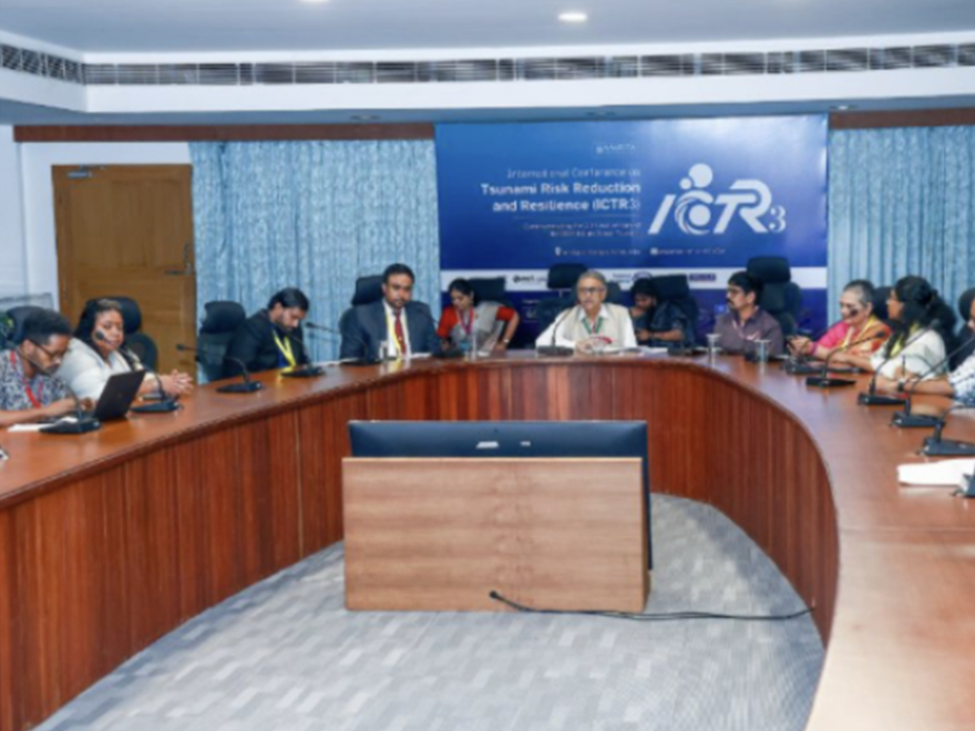
Odisha government officials convening for a formal meeting in a conference room focusing on governance matters.

SREE Geo-Spatial Platform: Community-Government Monitoring Integration

The SREE (Sustainability & Resilience Monitoring Platform) represents Amrita’s approach to informing regional governments through community-generated data. Operating in 1,200+ communities across 28 Indian states, SREE aggregates crowd-sourced vulnerability and resilience information and presents it through interactive dashboards accessible to municipal and state administrators.

Government Use Cases:

Municipal-Level Monitoring (Alappuzha, Kerala):
During the “Wave of Change: Water Sustainability Initiative” (March-April 2024), the municipality used SREE data to monitor:

  • Water table depths in each ward
  • Rainwater harvesting infrastructure status
  • Sanitation and water safety conditions
  • Community-identified vulnerabilities
Ward-Level Planning:

Municipal officials and ward leaders received real-time dashboards showing which specific neighborhoods faced water scarcity risks, enabling targeted allocation of water tankers, repair of distribution systems, and prioritization of rainwater harvesting installations.

State-Level Strategic Planning:

State governments access SREE’s aggregated data to:

  • Identify geographic clusters of vulnerability
  • Allocate disaster management resources proportional to risk
  • Track progress on climate resilience targets
  • Monitor effectiveness of adaptation interventions

SREE Platform Overview:
https://www.amrita.edu/news/sree-a-geo-spatial-platform-empowering-villages-for-sustainability-and-resilience/

Amrita Vishwa Vidyapeetham’s Early Warning Systems and Government Partnerships (2024)

Advisory Services and Capacity Building for Government Officials

Real-Time Dashboard Training and Operations

Amrita provides ongoing, continuous training for government staff on operating the early warning system dashboards and interpreting alert information. Training modules cover:

  • Dashboard navigation and data visualization
  • Alert interpretation and escalation protocols
  • Integration with emergency response procedures
  • Coordination with community communication channels
System Maintenance and Technical Support

Amrita offers 24/7 technical support for all deployed systems, ensuring minimal downtime and maximum reliability during critical periods. Government agencies receive:

  • Remote and on-site troubleshooting
  • Regular system audits and performance reviews
  • Hardware maintenance and sensor calibration
  • Software updates and security patches
Risk Assessment and Vulnerability Mapping Workshops

Quarterly workshops train government officials on advanced risk assessment techniques, including:

  • Multi-hazard vulnerability analysis
  • Impact modeling for different risk scenarios
  • Resource optimization for disaster preparedness
  • Integration of climate change projections into planning
Data Interpretation and Policy Briefings

Amrita provides regular briefings to senior government officials presenting:

  • Real-time risk trends and seasonal patterns
  • Lessons learned from recent disaster events
  • Comparative analysis across regions
  • Evidence-based policy recommendations
Emergency Response Coordination

During actual hazard events, Amrita researchers work directly alongside government emergency coordinators to:

  • Provide real-time hazard status updates
  • Advise on evacuation timing and routing
  • Support communication with affected communities
  • Document event impacts for recovery planning

Integration with Government Early Warning Protocols

Tiered Alert System for Government Response

Amrita’s early warning systems produce government-actionable alerts with clear escalation protocols:

Level 1 Alert (Green): Normal monitoring conditions; routine reporting to government agencies

Level 2 Alert (Yellow): Elevated risk indicators; standby alerts to district disaster managers; pre-positioning of emergency resources

Level 3 Alert (Orange): High-risk conditions; activation of emergency response teams; public alert dissemination; coordination with neighboring districts

Level 4 Alert (Red): Imminent hazard; immediate evacuation orders; full emergency activation; real-time government-community coordination

Government Communication Integration

Amrita works with government to integrate alerts into:

  • SMS/WhatsApp channels for rapid public notification
  • Radio and television broadcasting systems
  • Community loudspeaker networks in villages
  • School emergency response protocols
  • Hospital and rescue service activation systems

Scaling and Future Expansion of Government Partnerships

Multi-State Expansion (2025 Roadmap)

Amrita has identified over 10 additional states for early warning system deployment, with government feasibility assessments underway in:

  • Assam: Flash flood and earthquake risk
  • Himachal Pradesh: Landslide and snow-related hazards
  • Uttarakhand: Glacial lake and seismic risks
  • Meghalaya: High precipitation-triggered landslides
  • Arunachal Pradesh: Multi-hazard vulnerable regions
National Integration with Disaster Management Framework

Amrita is engaged in discussions with the National Disaster Management Authority (NDMA) to integrate its early warning systems into India’s national disaster management framework, standardizing technology deployment and protocols across states.

International Collaboration Model

The Amrita-government partnership model is being adapted for international contexts through collaborations with:

  • International Consortium on Landslides (ICL)
  • International Program on Landslides (IPL)
  • Regional government agencies in neighboring South Asian countries
Full Links Directory
Core Government Partnership Links:
  1. Sikkim State Disaster Management Authority Partnership (May 2025 MoU):
    https://www.amrita.edu/news/amrita-partners-with-sikkim-state-disaster-management-authority-strengthen-community-resilience-eastern-himalayas/
  2. Multi-Hazard Forecasting Platform for North Sikkim:
    https://www.amrita.edu/blog/forecasting-disasters-before-they-strike-how-amritas-risk-assessment-models-are-revolutionising-disaster-management-in-sikkim/
  3. Government Collaborations Repository:
    https://www.amrita.edu/unsdg-25/sdg13/colloborations/
  4. Odisha State Collaboration – Gajapati District:
    https://www.amrita.edu/news/odisha-government-collaborates-with-amrita-vishwa-vidyapeetham-to-implement-landslide-early-warning-system-in-gajapati-district/
  5. Odisha Partnership News (Amma.org):
    https://amma.org/news/protecting-lives-odisha-government-and-amrita-university-collaborate-for-landslide-early-warning-system/
  6. Kerala Government Approval for Wayanad System (Official G.O.):
    https://sdma.kerala.gov.in/wp-content/uploads/2025/07/G.O-RT-208-2025-Permission-granted-to-Amrita-Visha.pdf
  7. Wayanad Early Warning System Deployment:
    https://www.amrita.edu/news/ready-to-save-lives-exploring-deployment-of-our-landslide-early-warning-system-in-wayanad-kerala/
  8. SREE Geo-Spatial Platform for Community Monitoring:
    https://www.amrita.edu/news/sree-a-geo-spatial-platform-empowering-villages-for-sustainability-and-resilience/
  9. Disaster Management Training and Initiatives:
    https://www.amrita.edu/school/sustainable-futures/initiatives/disaster-management/
  10. Climate Action Plan and Monitoring:
    https://www.amrita.edu/unsdg-25/sdg13/climate-action-plan/

Amrita Vishwa Vidyapeetham’s comprehensive approach to informing and supporting local and regional governments combines pioneering technology deployment, long-term government partnerships, customized advisory services, and scalable capacity-building programs. Through these integrated efforts, the university has established itself as the preferred technical and strategic partner for disaster risk reduction and climate-resilient development across India’s most vulnerable regions.

  1. https://www.amrita.edu/blog/forecasting-disasters-before-they-strike-how-amritas-risk-assessment-models-are-revolutionising-disaster-management-in-sikkim/ 
  2. https://www.downtoearth.org.in/natural-disasters/stemming-the-landslide-heres-why-localised-early-warnings-in-india-still-an-uphill-battle 
  3. https://sdma.kerala.gov.in/wp-content/uploads/2025/07/G.O-RT-208-2025-Permission-granted-to-Amrita-Visha.pdf 
  4. https://www.amrita.edu/news/amrita-partners-with-sikkim-state-disaster-management-authority-strengthen-community-resilience-eastern-himalayas/ 
  5. https://www.amrita.edu/news/odisha-government-collaborates-with-amrita-vishwa-vidyapeetham-to-implement-landslide-early-warning-system-in-gajapati-district/ 
  6. https://amma.org/news/protecting-lives-odisha-government-and-amrita-university-collaborate-for-landslide-early-warning-system/ 
  7. https://www.amrita.edu/news/sree-a-geo-spatial-platform-empowering-villages-for-sustainability-and-resilience/ 
  8. https://www.amrita.edu/news/ready-to-save-lives-exploring-deployment-of-our-landslide-early-warning-system-in-wayanad-kerala/ 
  9. https://www.amritapuri.org/85353/24wayand.aum 
  10. https://nidm.gov.in/PDF/TrgReports/2024/September/Report_24-27September2024ga.pdf 
Admissions Apply Now